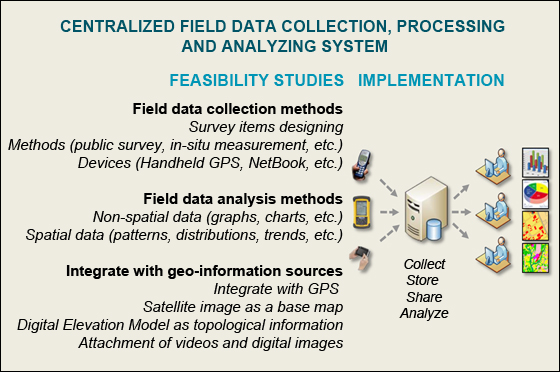
Development of centralized field data collection, processing and analyzing system for spatial information
users
Project Leader: Professor Dr. Yuji Murayama
Project Homepage
Outline of research
Field data collection is a first step requirement for any spatial
information users especially for human geographers, physical
geographers, geologists, crop scientists, ecologists, etc. Human
geographers may want to collect public opinions and social
activities, in order to understand social behaviors change over
space and time. Geologists or physical geographers may want to
collect in-situ data, in order to understand overall regional
geological formations and structures. This research/project aims to
explore extensively in field data collection and analysis methods
integrate with various geo-information sources (i.e., GPS,
satellite images, Digital Elevation Model, etc.) and multimedia
(i.e., videos and digital images, etc.). Based on extensive
feasibility studies, this project also aims to construct centralized
field data collection, processing and analyzing system which can
integrate, store, share, retrieve and analyze the collected field
data by utilizing modern spatial web technologies.
Mapping the human settlements using Remote
Sensing and GIS: A case of South East Asia cities
Project Leader: Professor Dr. Yuji Murayama
and Dr. Ko Ko Lwin
Outline of research
The main objective of this research is
to construct a semi-automatic spatial model which enables users to
generate the map of human settlements patterns based on low-cost
medium resolution remote sensing data in a timely manner.
Eco-friendly Walk Score
Calculator: Choosing a Place to Live with GIS
Project Homepage (About project)
Dr. Ko Ko Lwin and Prof. Dr. Yuji Murayama
Outline of research
The main purpose of this research is to propose an integrated
methodology (Remote Sensing, GIS and Spatial Web Technology) to
model urban green space walkability, which enables local residents
to make informed decisions that will improve their living conditions
and physical health related to the neighbourhood environmental
quality by integrating Advanced Land Observing Satellite (ALOS) data
and other GIS datasets. We use this spatial web technology to help
local residents make decisions related to neighbourhood
environmental quality, such as how to choose an eco-friendly living
space when buying a home or how to find the shortest or greenest
route to walk to improve their health.
Read more
about this research at
Computers, Environment and Urban
Systems Journal.
Read more about this research at The 5th Japan-Korea-China Joint
Conference on Geography (Green Society in East Asia: A Geographical
Contribution) conference, November 7-10, Tohoku University, Sendai,
Japan.
Online Demo in Japanese
Online Demo in English
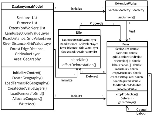
Modelling Deforestation in Dzalanyama Forest Reserve, Lilongwe, Malawi: Using Multi-agent Simulation Approach
Kondwani Godwin Munthali
Outline of research
Several parameters are recognized to influence agents of deforestation's decision-making to deforest. Physical environment strongly influences deforestation, and in the tropics, it is evident that many of these parameters hinge on agricultural household activities. Dzalanyama forest reserve covers 93,500 hectares and with increased urban demand for charcoal, there are marked land cover transitions in the forest reserve. Observed trends indicate that the forest cover as of 1990 was 65, 775 hectares of which 22,031 hectares were lost by the year 2010. The objective of this study is therefore to derive understanding of the underlying causes of deforestation in Dzalanyama and estimate the future of forest cover loss. I describe and develop a multi-agent simulation (MAS) to simulate the selections of cropping decisions and survival strategies on one hand and a competing labour practice of charcoal production by smallholder farming households surrounding the forest reserve. This study is further aimed at providing a socio-scientific basis for potential policy intervention scenarios towards sustainable management efforts of the forest reserve and other forest reserves in Malawi.
Spatial analysis of ecosystem service value changes in Baguio City, the Philippines, based on land use/cover changes
Ronald C. Estoque
Outline of research
Baguio city in the Philippines is the only hill station in Southeast Asia established by the Americans during the early 20th century to serve as a convalescent-cum-recreational center. Due to its rapid urbanization in recent decades, Baguio’s natural environment, fragile ecosystems (e.g. forests) and the ecosystem services and amenities they provide (e.g. gas/climate regulation, water supply and regulation, recreation and cultural) are now in jeopardy. There is hence an urgent need to study its status and the trend of landscape changes in this hill station before further irreparable environmental damage occurs.
The main objective of this study is to project future land use/cover (LUC) and ecosystem service value (ESV) changes in Baguio city, and elucidate their implications for future landscape conservation and urban development planning. The natural environment and ecosystem services of Baguio city are extremely important in fulfilling many important roles, including those of the summer capital and a major tourist destination of the country.

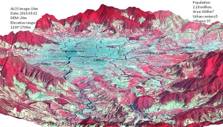
Spatial process of urbanization in Kathmandu Valley, Nepal
Dr. Rajesh Bahadur Thapa
Outline of research
Kathmandu, a bowl shaped valley is interesting case to study as it consists of topographic constraints for horizontal urban expansion but facing rapid urbanization. Kathmandu is main political center, major tourist gateway and economically strategic place in Nepal. High population growth, dramatic land use changes and socioeconomic transformation have brought the paradox of both rapid urbanization and environmental consequences in the valley. Along with new developments within the city fringes and rural villages, shifts in natural environment and newly developed socioeconomic strains between residents are emerging. Such rapid demographic and environmental changes and weak land use planning practices in the past decades have resulted in environmental degradation, haphazard landscape development, and stress on ecosystem structure. I am addressing these problems focusing research on investigating the urbanization process, modeling of land change, and scenario based urban growth allocations.
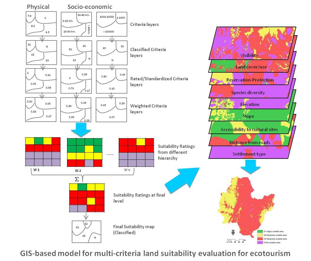
Suitability Evaluation for Ecotourism using GIS & AHP: a case study of Surat Thani Province, Thailand
Bunruamkaew Khwanruthai (Pai)
Outline of research
This research aims to identify and prioritize the potential ecotourism sites using AHP integrated
in GIS. It is imperative that only some areas are suitable for ecotourism to be developed and
ensure that ecotourism criteria are matched with the basic resource characteristics of the area. The
integration of the AHP in GIS combines decision support methodology with powerful visualization
and mapping capabilities which in turn should considerably facilitate the creation of land use
suitability map.
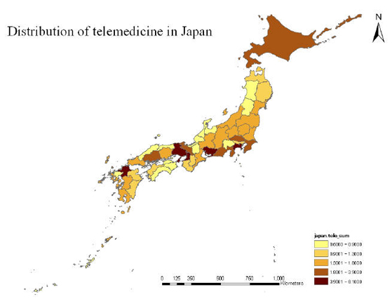
Telemedicine study
SooKyung Park
Motivation
Even though the demand of telemedicine has been increased in
Japan, there are a few previous researches about it, including a
geographical perspective. Considering its history and needs in the
contemporary society, it is a considerable research that examines
the conjunction between medical systems and telecommunication
infrastructure.
Outline of research
This research is based on two types of telemedicine; urban and
rural areas. In general, the ultimate goal of telemedicine was
originated as the supporting system for stable medical services of
rural areas. In particular, there are a lot of physical limitations
in Japan and telemedicine is a new innovative technology for medical
services in rural areas. And with developing technologies, urban
areas need telemedicine technologies considering patients' travel
time and burden. Basically, a geographical perspective considers the
synthetic approach for a certain social phenomenon. The result of my
research will devote to suggest a new idea for telemedicine.
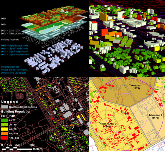
Online Micro-spatial Analysis based on GIS Estimated Building Population: A Case Study of Tsukuba City
Ko Ko Lwin and Prof. Dr. Yuji Murayama
Outline of research
The main objective of this research
is to develop online micro-spatial analytical functions based on GIS
estimated building population by utilizing modern Remote Sensing
data acquisition system and GIS technologies such as LIDAR (Light
Detection and Ranging) data and building footprints to improve the
accuracy in micro-spatial analysis as a case study of Tsukuba City.
Sample demo:
Online Interactive Micro-spatial Population Analysis (SPA /
Micro SPA; online interactive micro-spatial population analysis
based on GIS estimated building population as a case study of part
of the Tsukuba City)
A GIS Tool: Download
PopShapeGIS (A GIS Tool for Estimation of Building Population)
Reinforcing Landscape Rehabilitation using Visibility Analysis: A Case Study of Western Liguria, Italy
Matteo Gismondi
Outline of research
This paper introduced a method in analysing landscape management using visibility analysis as a tool to preserve the local identity in Region Liguria.
The results of this study show certain patterns reflecting the fragility of the territory due to the abandonment of the countryside and lack of planning. The coastal areas lack green spaces due to continuous development and is becoming a perpetual urban block concentrated solely within the first kilometre of the coast. These municipalities are progressively losing their historical rural identity in the coastal areas because of the rapid and uncontrolled development. On the other hand in the hinterland, identity is still retained within the municipalities due to the relatively slow progress in development.
The rapid development of the coastal cities is pushing the residents to migrate from the small rural villages to the coastal zones. This is portrayed as the main reason to the abandonment of the typical culture of the area; associated with the lack of forest keeping, provoking damages to the landscape. However, it is possible to find the typical factors that identify and characterize the Liguria region in areas such as the province of Imperia (including the SS28) and within the hinterlands. Nevertheless, in all of the tracks taken in consideration, the level of abandonment is very high.
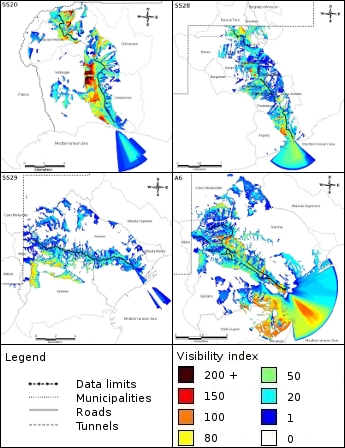 Figure - Visibility analysis results
Investigating the rural community behaviour after the 2004 Chuetsu earthquake. A case study of Kawaguchi town, Japan
Matteo Gismondi
Outline of research
Earthquakes are a global threat causing every year economical and human losses. In Japan, major attention ha been focused in the last decade to improve the safety of structure and citizens with a constant introduction of policies raising the level of security nationwide. Despite this strong effort, major lacks still appear in preparation and awareness of people, especially in rural areas where the technological advancement and the policy application are late to arrive. In this paper Kawaguchi town in Niigata Prefecture, Japan is chosen as representative of the rural areas having major damages during the 2004 Chuetsu Earthquake. This paper aims to investigate the causes behind the regional differences in community behaviour after the earthquake, using interviews and questionnaires to collect information. The spatial environmental conditions such as geographical location, everyday relations, social interaction and organisation are considered the main causes explaining the differences in community organisation during the recovery process, highlighting the necessity of a more localised emergency education in order to provide a durable awareness and preparation in rural areas.
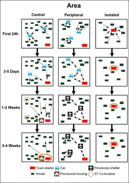 Figure - Differences in movement behaviour over time
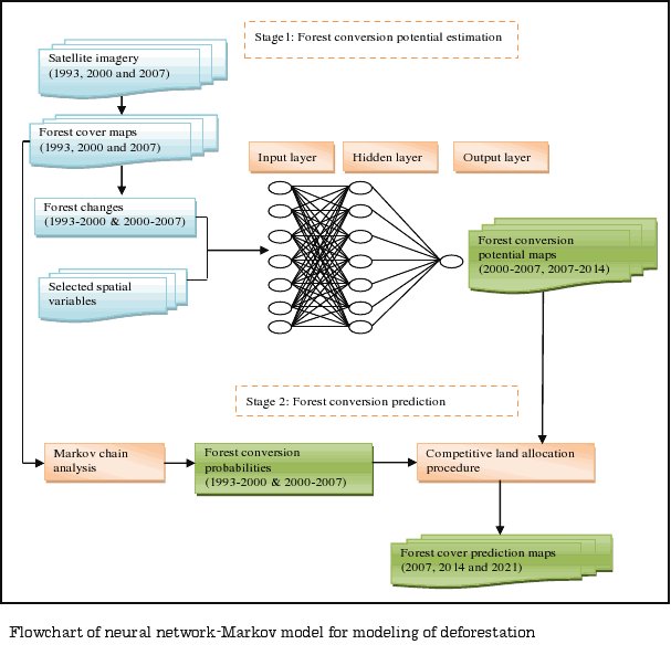
Spatial Modeling of Deforestation in Tam Dao National Park Region, Vietnam
Duong Dang Khoi
Outline of research
Deforestation is increasingly causing changes in ecological, hydrological and climatic processes at
both the local and global scales. It is occurring at an alarming rate in many parts of the world,
especially in developing countries. Monitoring and predictive modeling of deforestation is essential
for protected area setting. Tam Dao National Park (TDNP) is a remaining primary forest that
supports some of the highest levels of biodiversity in Vietnam. Forest conversion due to illegal
logging and agricultural expansion is a major problem that is hampering biodiversity conservation
efforts in the TDNP region. In this study, I am interested in the use of remote sensing and neural
network-Markov chain model for spatial modeling and prediction of forest cover in the region.
Previous researches in pdf