|
研究動向
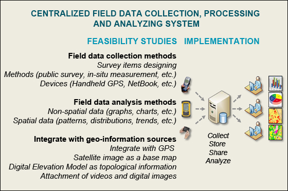
Development of centralized field data collection, processing and analyzing system for spatial information
Project Leader: Professor Dr. Yuji Murayama
Outline of research
Field data collection is a first step requirement for any spatial
information users especially for human geographers, physical
geographers, geologists, crop scientists, ecologists, etc. Human
geographers may want to collect public opinions and social
activities, in order to understand social behaviors change over
space and time. Geologists or physical geographers may want to
collect in-situ data, in order to understand overall regional
geological formations and structures. This research/project aims to
explore extensively in field data collection and analysis methods
integrate with various geo-information sources (i.e., GPS,
satellite images, Digital Elevation Model, etc.) and multimedia
(i.e., videos and digital images, etc.). Based on extensive
feasibility studies, this project also aims to construct centralized
field data collection, processing and analyzing system which can
integrate, store, share, retrieve and analyze the collected field
data by utilizing modern spatial web technologies.
Eco-friendly Walk Score
Calculator: Choosing a Place to Live with GIS
Dr. Ko Ko Lwin and Prof. Dr. Yuji Murayama
Outline of research
The main objective of this
research is to find potential living area in Tsukuba City by
providing greenness score and available public facilities by walking
or cycling, in order to reduce cooling and heating demands, cutoff
fuel consumption, improve air quality and human physical health,
eliminate social isolation, and avoid urban heat island effect. This
research integrates the Advanced Land Observing Satellite (ALOS)
data with GIS Network Model for calculation of green density,
finding shortest or greenest path and choosing a place to live in
Tsukuba City through interactive Web-GIS.
Read more
about this research at Computers, Environment and Urban
Systems Journal.
Read more about this research at The 5th Japan-Korea-China Joint
Conference on Geography (Green Society in East Asia: A Geographical
Contribution) conference, November 7-10, Tohoku University, Sendai,
Japan.
Online Demo in Japanese
Online Demo in English
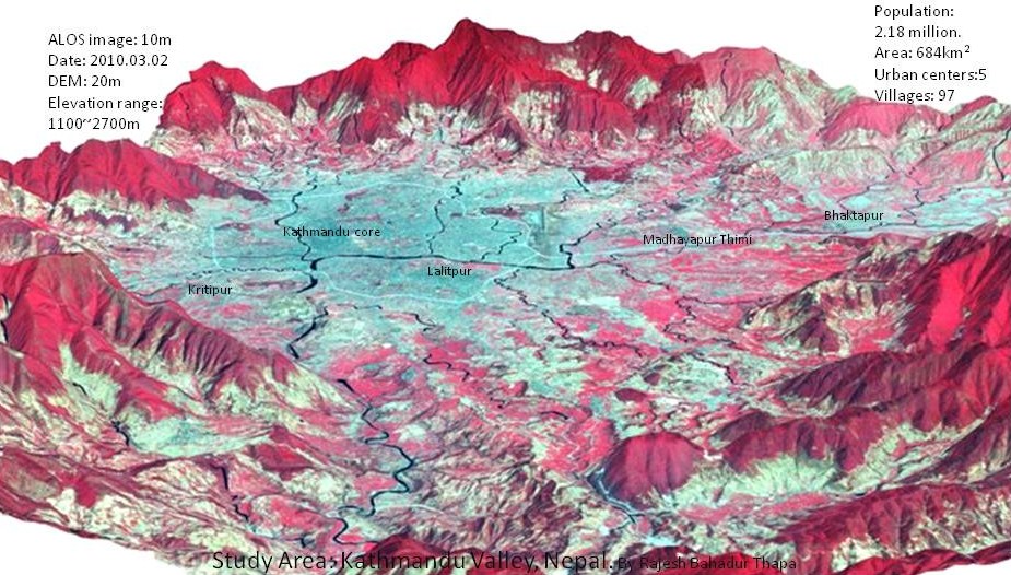
Land-use change in Kathmandu Valley, Nepal
Dr. Rajesh Bahadur Thapa
Outline of research
Kathmandu, a bowl shaped valley is interesting case to study as it consists of topographic constraints for horizontal urban expansion but facing rapid urbanization. Kathmandu is main political center, major tourist gateway and economically strategic place in Nepal. High population growth, dramatic land use changes and socioeconomic transformation have brought the paradox of both rapid urbanization and environmental consequences in the valley. Along with new developments within the city fringes and rural villages, shifts in natural environment and newly developed socioeconomic strains between residents are emerging. Such rapid demographic and environmental changes and weak land use planning practices in the past decades have resulted in environmental degradation, haphazard landscape development, and stress on ecosystem structure. I am addressing these problems focusing research on investigating the urbanization process, modeling of land change, and scenario based urban growth allocations.
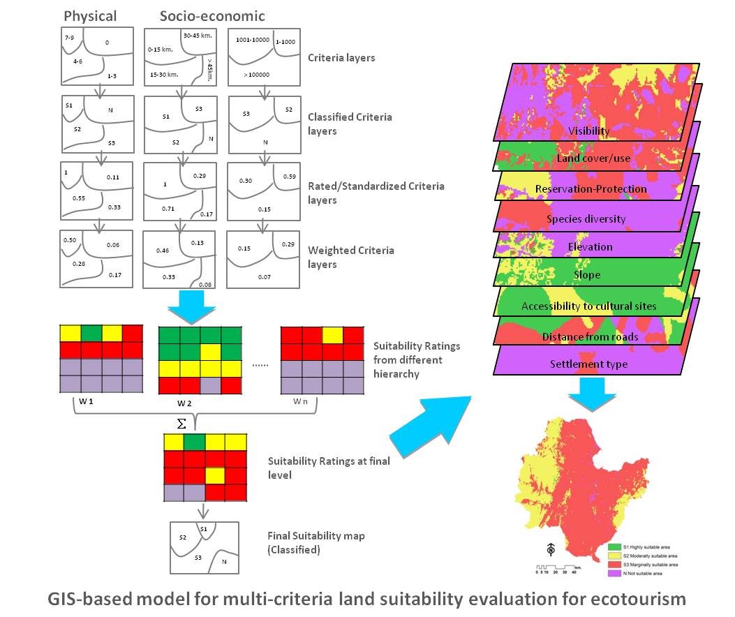
Suitability Evaluation for Ecotourism using GIS & AHP: a case study of Surat Thani Province, Thailand
Bunruamkaew Khwanruthai (Pai)
Outline of research
This research aims to identify and prioritize the potential ecotourism sites using AHP integrated
in GIS. It is imperative that only some areas are suitable for ecotourism to be developed and
ensure that ecotourism criteria are matched with the basic resource characteristics of the area. The
integration of the AHP in GIS combines decision support methodology with powerful visualization
and mapping capabilities which in turn should considerably facilitate the creation of land use
suitability map.
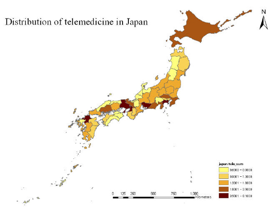
Telemedicine study
SooKyung Park
Motivation
Even though the demand of telemedicine has been increased in
Japan, there are a few previous researches about it, including a
geographical perspective. Considering its history and needs in the
contemporary society, it is a considerable research that examines
the conjunction between medical systems and telecommunication
infrastructure.
Outline of research
This research is based on two types of telemedicine; urban and
rural areas. In general, the ultimate goal of telemedicine was
originated as the supporting system for stable medical services of
rural areas. In particular, there are a lot of physical limitations
in Japan and telemedicine is a new innovative technology for medical
services in rural areas. And with developing technologies, urban
areas need telemedicine technologies considering patients' travel
time and burden. Basically, a geographical perspective considers the
synthetic approach for a certain social phenomenon. The result of my
research will devote to suggest a new idea for telemedicine.
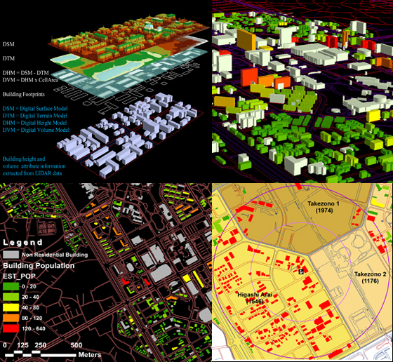
Online Micro-spatial Analysis based on GIS Estimated Building Population: A Case Study of Tsukuba City
Dr. Ko Ko Lwin and Prof. Dr. Yuji Murayama
Outline of research
The main objective of this research
is to develop online micro-spatial analytical functions based on GIS
estimated building population by utilizing modern Remote Sensing
data acquisition system and GIS technologies such as LIDAR (Light
Detection and Ranging) data and building footprints to improve the
accuracy in micro-spatial analysis as a case study of Tsukuba City.
Sample demo:
Online Interactive Micro-spatial Population Analysis (SPA /
Micro SPA; online interactive micro-spatial population analysis
based on GIS estimated building population as a case study of part
of the Tsukuba City)
A GIS Tool: Download
PopShapeGIS (A GIS Tool for Estimation of Building Population)
Reinforcing Landscape Rehabilitation using Visibility Analysis: A Case Study of Western Liguria, Italy.
Matteo Gismondi
Motivation
When travelling by road, the visible landscape can be considered as a window of the surrounding areas and is the media by which the knowledge of the territory aims portrayed. In Liguria (NW of Italy), the Regional Council is to proceed with concrete actions aiming at re-qualifying and protecting of the landscape, which is a vector of local identity and a creator of the socio-economic situation. The paper proposes a method to model the zones visible from the roads using visibility analysis and land-use data in order to understand which areas are under the tourist's view and are the most representative of the local culture. The progressive degradation of the territory such as abandonment and forest fire is the symptom of the weakness of the territory which will lead to the complete loss of the territorial tradition that distinguish these territories if not properly protected. By receiving concrete information on the actual situation of the West Ligurian territories, it is possible to engage in more specific actions aiming to re-qualify and protect the landscape. This method encompasses a flexibility that can be applied to other locations where landscape management is needed.
Outline of research
This paper introduced a method in analysing landscape management using visibility analysis as a tool to preserve the local identity in Region Liguria.
The results of this study show certain patterns reflecting the fragility of the territory due to the abandonment of the countryside and lack of planning. The coastal areas lack green spaces due to continuous development and is becoming a perpetual urban block concentrated solely within the first kilometre of the coast. These municipalities are progressively losing their historical rural identity in the coastal areas because of the rapid and uncontrolled development. On the other hand in the hinterland, identity is still retained within the municipalities due to the relatively slow progress in development.
The rapid development of the coastal cities is pushing the residents to migrate from the small rural villages to the coastal zones. This is portrayed as the main reason to the abandonment of the typical culture of the area; associated with the lack of forest keeping, provoking damages to the landscape. However, it is possible to find the typical factors that identify and characterize the Liguria region in areas such as the province of Imperia (including the SS28) and within the hinterlands. Nevertheless, in all of the tracks taken in consideration, the level of abandonment is very high.
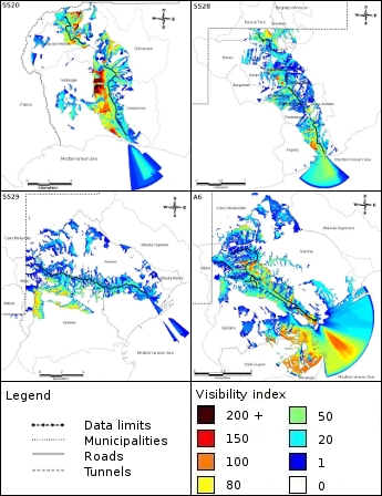 Figure - Visibility analysis results Figure - Visibility analysis results
Previous researches in pdf
|
|